The Volusia flood watch covering inland and coastal areas begins Tuesday, November 17, at 5 p.m. Eastern Standard Time, while a separate river flood warning is already in effect near Astor. The National Weather Service lists the rainfall watch through Friday, November 20, at 7 p.m. EST. A separate high-surf advisory begins Tuesday at 7 p.m. EST, with breaking waves of 5-10 feet forecast along the named coastal area.
Rainfall, river flooding and coastal surf have different geographic limits. Possible flooding from approaching rain is the concern in the Volusia flood watch. The Astor warning concerns existing conditions on the St. Johns River near the Volusia-Lake county boundary. Neither should be substituted for the other when checking a location.
Volusia flood watch and three other alerts compared
The following comparison uses the official NWS alert records retrieved Tuesday morning, November 17. All times in the table are EST, the local time in Volusia County.
| Official product | Area relevant to this guide | Timing stated in the record | What it establishes |
|---|---|---|---|
| Flood Watch | Inland and coastal Volusia, within a larger east-central Florida watch | Nov. 17, 5 p.m., through Nov. 20, 7 p.m. | Flooding from excessive rainfall is possible |
| Flood Warning | St. Johns River near Astor, affecting Volusia and Lake counties | Continuing until further notice | Minor flooding is occurring; minor to moderate flooding is forecast |
| Rip Current Statement | Coastal Volusia and other named east-coast beaches | Through Nov. 19, 7 p.m. | Dangerous rip currents; the end is one day later than the prior product |
| High Surf Advisory | Coastal Volusia and other named east-coast areas | Nov. 17, 7 p.m., through Nov. 19, 1 p.m. | Breaking waves of 5-10 feet are forecast in the surf zone |
For readers coordinating from outside Florida, the Volusia flood watch starts at 4 p.m. Central and ends at 6 p.m. Central. The river warning is not a countywide statement that every Volusia road or neighborhood is flooded. The two coastal products concern the shore rather than inland river levels. Their ending times differ: Thursday at 1 p.m. for high surf and Thursday at 7 p.m. for the rip-current risk.
NWS’s Astor warning was issued at 8:24 p.m. EST Monday. It has a message expiration of 11 a.m. Tuesday, but its stated hazard duration is until further notice. That expiration is not a promise that river flooding will end Tuesday morning. Check the replacement or continuing river product.
The rainfall numbers cover different areas
The Volusia County notice published November 16 describes a forecast of 4-6 inches through Friday, with locally higher amounts possible. It identifies coastal communities, including areas east of I-95 and south of I-4, as having greater potential for heavier rain.
The broader NWS watch describes 3-6 inches across its east-central Florida area, with localized amounts of 8-12 inches possible and the greatest potential for those higher totals along coastal counties. These are overlapping regional and county forecasts. They should not be added together or presented as rainfall already measured at a house.
The county places the most significant rainfall potential Wednesday evening through Friday. The Volusia flood watch starts earlier, Tuesday afternoon. Waiting for the county’s expected heaviest period would overlook the beginning of the official watch window.
The NWS Melbourne forecast discussion, in its 2:16 a.m. EST Tuesday discussion, identifies the new surf advisory and increasing coastal hazards. Forecasters expect beach erosion that could reach moderate severity, with major erosion possible in some locations. This is a forecast, not a report that a particular property has flooded or a beach has already eroded.
The coastal extension is not the rainfall-watch deadline
The November 17 coastal products keep the rip-current risk high until Thursday evening, November 19. The earlier record used in this guide ended that risk Wednesday evening. That is a 24-hour extension of the stated end, not an extra day added to the rainfall watch.
Subtracting the surf advisory’s published start and end gives a 42-hour window: Tuesday at 7 p.m. through Thursday at 1 p.m. EST. These are product timings, not an estimate of how long any individual beach will experience a particular wave height.
Both coastal records were issued at 1:28 a.m. EST Tuesday. The combined statement includes high-surf and rip-current information, but the separate named products retain different end times. Read the hazard and the time together rather than assigning one deadline to every line.
Astor has a river problem before the new rain
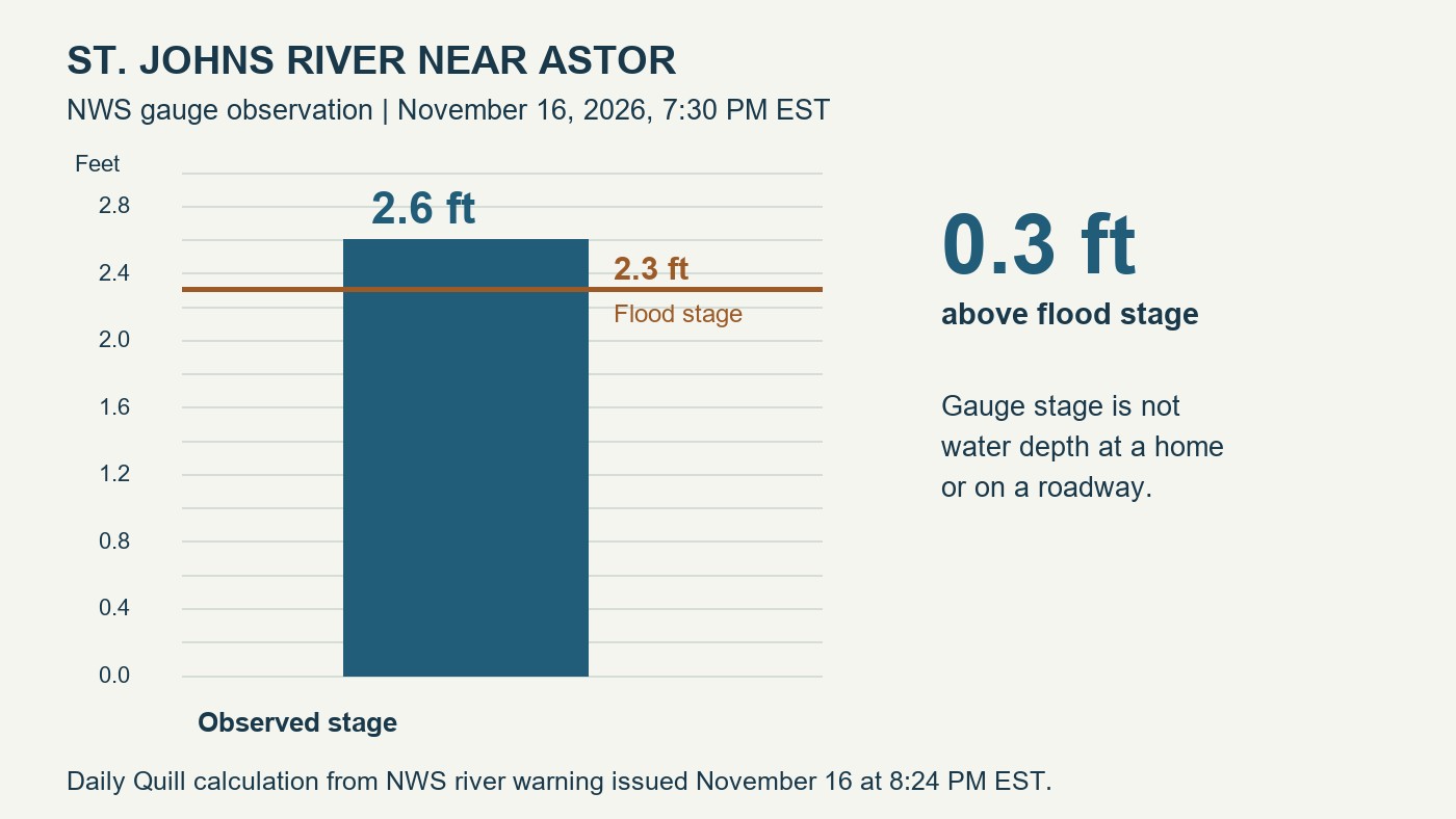
NWS reported a river stage of 2.6 feet near Astor at 7:30 p.m. EST Monday, compared with a flood stage of 2.3 feet. The difference is 0.3 feet above that gauge’s flood-stage threshold. It is not a measurement of water depth inside a home or over a road.
The warning forecasts slight rises within minor flood stage into midweek, with the possibility of moderate flood stage later in the week. The county separately notes that upstream rain can affect Volusia because the St. Johns flows north. The timing and location of additional rainfall remain important uncertainties.
For businesses documenting earlier storm impacts, the Florida flood survey guide explains a separate official reporting process. Completing a survey does not establish that a road or property is safe. The Science and Environment desk carries related reporting.
Volusia County advises residents to review household plans and supplies and avoid roads covered by standing water. NWS’s current coastal statement discourages entering the rough surf and directs readers to beach patrol flags, signs and lifeguard advice. Before Tuesday’s watch begins, check the current NWS product for the relevant river, inland or coastal location; the county notice also directs residents to the Volusia Emergency Management app for updates.